A tale of two megaliths

Site location
Fig 1: site location (marked in blue).


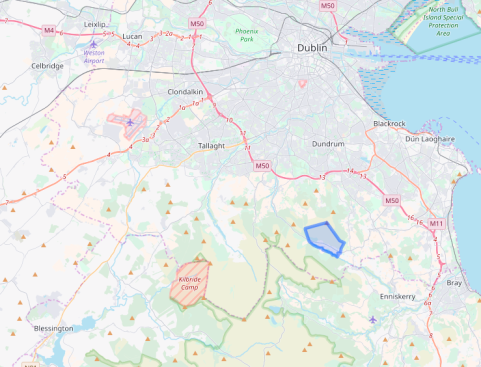
Ballybrack townland is close to the Wicklow county border in south Dublin (fig. 1). Its boundary encompasses an expanse of upland heath strewn with innumerable granite boulders and outcrops. Turf cover is thin, and at the lowest elevations, rough pastures provide occasional grazing. The townland is roughly basin shaped with flanks to the east and west rising up to create the backdrop of Two Rock mountain (536m OD). The two flanks embrace the warmer aspect of the southwest, and evening sunlight persists here for much longer than in the populated district below.

P1030183
Plate 1:  the ‘Fairy Castle’ on the summit of Two Rock mountain (facing north towards Dublin).

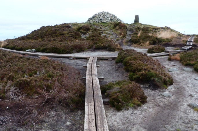
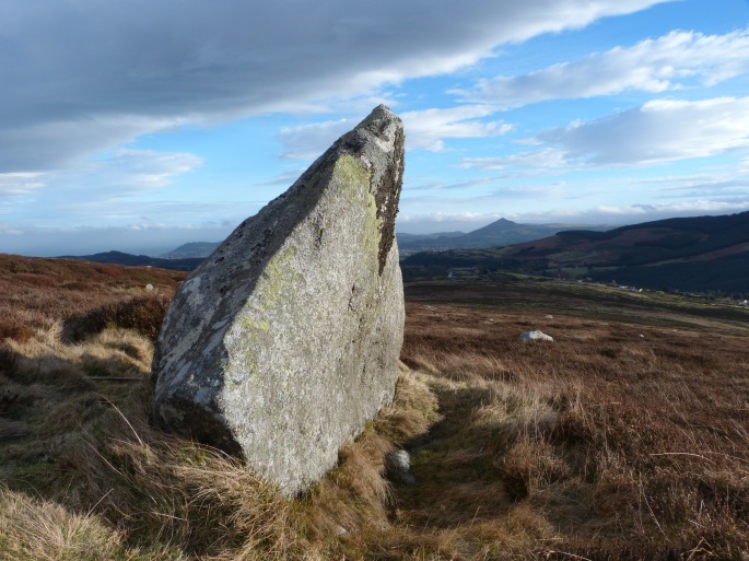
The Fairy Castle on the summit of Two Rock is a substantial cairn that is widely understood to house a passage tomb (plate 1). Views from this summit are exceptional: the plains of Dublin, Kildare, and Meath are laid out below. All of the Dublin bay islands are visible; as is most of the Irish Sea coast to the north, and south to Bray. The Mourne mountains can be easily seen most days, and the associated Dublin/Wicklow passage tombs and even the mountains of Snowdonia – weather permitting. Below and to the south of the Fairy castle, the land falls quite gradually in a series of undulating terraces down towards the Glencullen river.


P1060486

IMGP5991
Plates 2 & 3: examples of stone-cleaving remains on Two Rock mountain

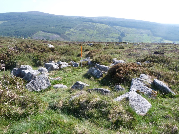
This place has had a distinct appeal to this visitor for many years, culminating in a formal examination of the work of the many generations of stonecutters who worked granite on these hillsides. They cut the granite by hand, and supplied roughed out orthogonal baulks to the Dublin stonemasons (plates 2 & 3). This raw material was ultimately fashioned into the street furniture that gives the city so much of its rapidly vanishing character; the paving slabs of the Georgian squares, steps, wall copings, window sills and so on. Many of these undervalued things came into being on these hillsides. Prior to, and during field work for that paper, it became abundantly clear that there are substantial quantities of extant prehistoric remains distributed throughout the townland. One of the most interesting appeared out of the mists some years ago. It is a massive, well weathered granite boulder supported at the back by three granite slabs laid flat, one on top of the other. There are two upright stones or orthostats that elevate the front, and a third appears to have been dislodged. Beneath the capstone there is no distinct chamber or any other form of internal division.

This was not the first time that the structure had been identified. The arrangement was first recorded and illustrated in 1852 by the artist and antiquarian Henry O’Neill (1798 – 1880) who wrote:

On the hill at the Dublin side of Glencullen I discovered a rock monument. The roof rock is ten feet long, eight feet broad and four feet thick, extreme measures; the longest direction of the roof rock is W.S.W, or nearly E. and W. The chamber is greatly disarranged’ (1852:43).

The ‘rock monument’ today fits the dimensions recorded by O’Neill, as does its morphology, except for the missing blocking stone (extreme left in figure 1).

O'Neil & Sands
Figure 1: Henry O’Neill’s 1852 illustration, and with Dr. Rob Sands – 2016.

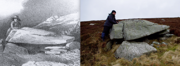
Portions of the structure have become obscured by the blanket bog since O’Neill’s impression – or he may have taken artistic liberties to emphasise its megalithic presence. It is probably more of a surprise that any of its components survive at all, given the scale and duration of stone exploitation on this hillside. The wedge tomb at nearby Ballyedmonduff (and at approximately the same elevation) was partially robbed out by the stonecutters. On the other hand, the absence of signs of exploitation could underline the possibility that the monument was known to the stonecutters, and afforded some protection by the lore that has saved so many of our monuments.

Forty-five years after O’Neill published the engraving, William Copeland Borlase supposes that:

In the town land of Ballybrack, adjoining that of Ballyedmonduff on the SW and Parish of Kilgobbin, is a dolmen marked Giant’s Grave in Ord. Surv. Map No. 25. It is half a mile WNW of Glencullen House, a quarter of a mile N of the Glencullen river, on the NE slope of Two-Rock mountain, the sides of which latter are covered with circles and tumuli. I suppose this is the same dolmen to which Mr. Henry O’Neill alludes as being on the Dublin side of Glencullen.’(1897:388).

From this point onwards, the whereabouts and existence of the monument becomes distinctly problematic, and largely ignored. Borlase’s directions pinpoint the Giant’s Grave site with some precision; O’Neill’s description by contrast, is decidedly vague. ‘…the hill on the Dublin side of Glencullen…’ amounts to most of the side of a glacial valley and encompasses an area of about eight square kilometres. Both O’Neill and Borlase reported on the ‘rock monument’ some time after the ‘Giant’s Grave’ had vanished. When Eugene (O’) Curry visited the locality in 1837 to gather information about local antiquities for the Ordnance Survey, he recorded the following:

The Giant’s grave at Ballybrack is but little known, though it appears to have been partly opened, but not within the memory of Peter Welsh, who lives near it, and is now 90 years old. It is situated on the top of a little cultivated hill and covered with a stone 10 feet by 7. No person in the neighbourhood ever heard any name for it but Peter Welsh, who when he was a boy heard the ould Irish people call it LEABA NA SAIGH (the greyhounds bed). This name must have originated in one of those popular fireside stories about spirits appearing in the shape of greyhounds etc.
(14 C 21 49/50, Letter from Eugene Curry to Lieut. Thomas A. Larcom 13th July 1837).

The crucial fact at this point is the mention of Peter Welsh’s proximity to the Ballybrack Giant’s Grave. Griffith’s valuation records a Walsh household just a few fields away from the site in 1849. The surname Walsh is often pronounced Welsh, so it may be reasonable to conclude that this was the family home of Peter Welsh/Walsh and that the nearby monument he described as Leaba na Saighe is the same one depicted on the first edition map. There is no doubt that Welsh’s Leaba na Saighe and O’Neill’s ‘rock monument’ are two entirely separate features. This is emphasised by Paul Walsh of the Megalithic Survey who notes in the entry for DU025-044 that a number of other writers ‘incorrectly assumed that the O’Neill site and this monument were one and the same’ (National Monuments Service 2014). Without visiting both sites, it would be an easy mistake to make. The essential arrangement was similar in both instances, the dimensions were very similar, and they were relatively close to each other.

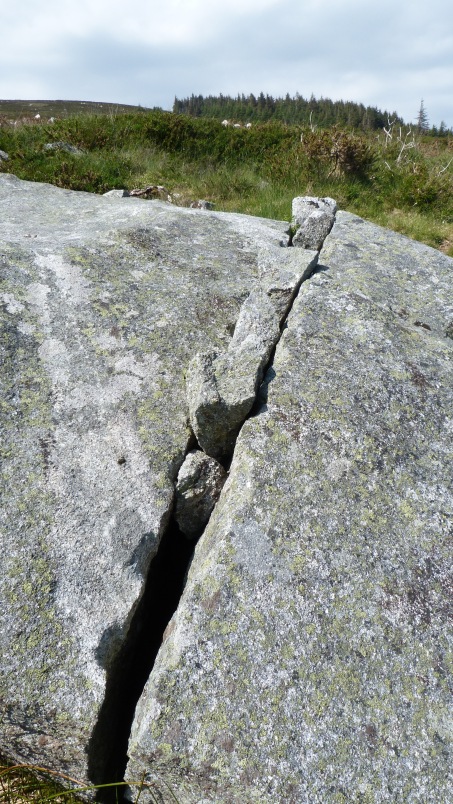
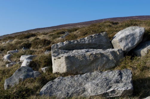
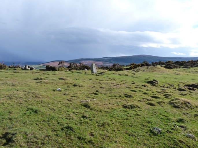
Ballybrack is an Anglicisation of an Baile Breac or the Speckled Town. The speckling probably refers to the masses of bleached granite field stones (‘wild stones’ in the stonecutters’ vernacular) that stand out against the muted hues of heathers and bog. Almost every one of these stones seems to have been exploited by stonecutters, and there are many places where their work has left unlikely arrangements of stone; some of which resemble megaliths or other forms of prehistoric stone construction. A recent visitor to Ballybrack saw one of these formations, assumed it was O’Neill’s monument, and forwarded their findings to the Monuments Survey (pers. comm. Paul Walsh). The feature they saw was either natural or a by-product of stone-cleaving. It was an easy mistake to make. Some of the formations, especially where stonecutters exploited massive slabs, have a morphology that could easily be misinterpreted as a megalithic structure (plate 4).

DSC_0117 copy
Plate 4: example of a potentially misinterpreted stone arrangement (Kenny 2013).

The monument is now recorded as a ‘megalithic structure’ (DU025-088). To what class it belongs is another matter. In overall form, it is probably closer to a boulder monument than any other monument type. The roof boulder is set on three or more support stones, all are less than a metre tall, and there is no surviving evidence for the existence of a covering cairn or any clearly defined chamber on the interior. These criteria fit well with Ó Nuallain’s observations on the morphology of the Cork and Kerry boulder burial group (1978, 76-77).

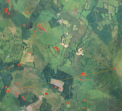
Boulder burials  are predominantly concentrated in south west Ireland and are typically associated with the Bronze Age (see also Roaringwater Journal for a discussion on the term burial). There is just one boulder burial recorded in Leinster: at Motabeg near Enniscorthy, county Wexford (WX026-014). However, there appears to be a clear pattern in the distribution of a range of megalithic classes in Leinster. There is a distinct concentration on the west and north-facing edges of the Leinster massif (Fig. 2).

Leinster distribution
Figure 2: distribution of primary prehistoric monuments in Leinster (Kenny 2018)

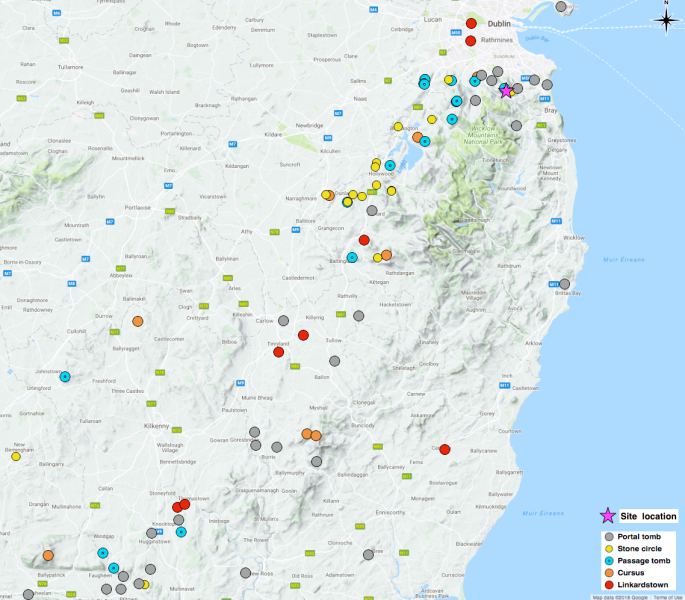
It is highly probable that this concentration is a consequence of deliberate situation with views to or from the north and west with intervisibility of the monuments, rather than simple survival. The western edge of the Leinster massif has been subjected to just as many intrusive cultural activities as the east and similar monuments, had they been built there, would just as likely survive today. Taking these hypotheses into account, it is possible to see that the rock monument fits very well into the overall distribution pattern. Of course distribution offers a limited insight into the situation or nature of an individual monument but in this case it does at the very least indicate that we should not be surprised to find a similar monument in this area.

In conclusion, O’Neill’s rock monument became confused with a similar monument that was once nearby. This happened for a variety of reasons that ultimately led to an assumption that the monument was lost, never existed, or had been misinterpreted in the first instance.
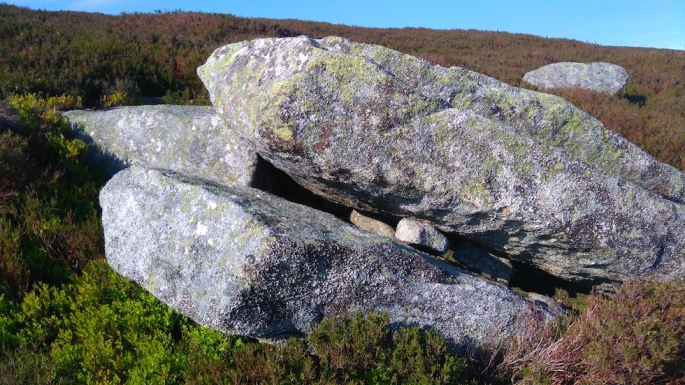
The monument survives intact and is almost identical to the one illustrated in 1852. It is a difficult monument to classify because it has elements that belong to several classes. The massive capstone is reminiscent of the enormous effort required to raise a portal tomb capstone, but the arrangement of supporting stones disallows that classification. Its arrangement and overall morphology fit well with the typology of boulder burials, but it would be an outlier in the distribution of that monument class. However, the possibility that it is a boulder burial is not necessarily precluded by how it fits into the distribution pattern. The context too, may provide support to the belief that this is a boulder burial. The surrounding landscape contains a considerable number of closely associated monuments and features that are almost certainly Bronze Age in date (Kenny 2018 forthcoming) and boulder burials are widely thought to fit within that period (plates 5 – 7).

P1060489
Plate 5: hut site close to the megalith.
P1050679
Plate 6: standing stone circa 100m from the megalith.
P1060421
Plate 7: the nearby Newtown complex.


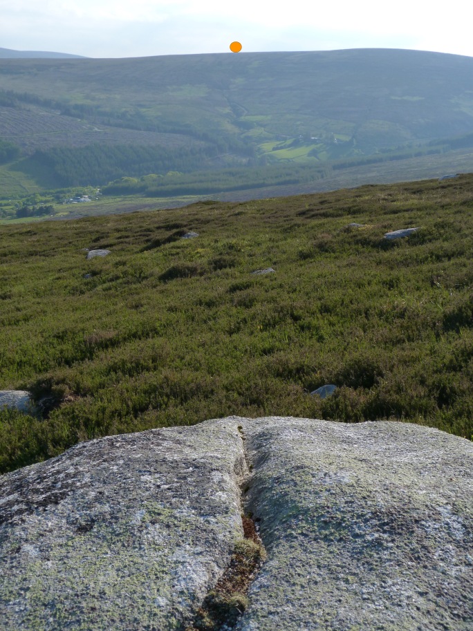
As a post script, one other feature of the monument should be mentioned. A groove on the upper surface of the capstone is strikingly similar to a possible solstice alignment identified by Brigid O’Brien (Finlay 2016). The groove on the Ballybrack capstone aligns with the winter solstice setting sun at a point on the horizon above the origin of a watercourse (plate 8). The groove is too eroded to determine if it was cut or naturally formed but in either case, it may have influenced the choice and orientation of the roof stone.

winter boulder solstice
Plate 8: the dorsal surface groove and the location of the winter solstice sunset on the horizon. Image based on information supplied by photoephemeris.com (Kenny 2016)


Further reading;
Borlase, W.C. 1897 The Dolmens of Ireland. Vol 2. London.
Finlay, F. 2016. Boulder Burials: a misnamed monument? Roaringwater Journal. Available at https://wordpress.com/read/feeds/13587098/posts/1005975143
O’Donovan, J. Petrie, G., Du Noyer, G.V. et al, 1837. Ordnance Survey of Ireland: Letters, Dublin. MS 14 C 21 49/50 Letter from Eugene Curry to Lieut. Thomas A. Larcom 13th July 1837
O’Neill, H. 1852 The Rock Monuments of the County of Dublin. Transactions of the Kilkenny Archaeological Society, Vol. 2, No. 1. Pp 42 – 46.


Another upland cursus monument.

Cursus monuments have largely been ignored in Ireland. This is a curious omission in the study of Neolithic earthworks, given the scale of this monument class and it may well be a product of the fact that the limited number of examples makes classification problematic. The upland cursus identified over the past two years have improved the knowledge base considerably but equally, they raise significant questions about function, classification and indeed, the value of the term itself. The term ‘cursus’ was first applied to the linear earthwork at Stonehenge by the antiquarian, William Stukeley (1687 – 1765). Stukeley misinterpreted the Stonehenge monument as a Roman racecourse and this may be one reason for lingering doubt about the authenticity of this monument class – in much the same way as it has been unfashionable to entertain ideas of an established Roman presence in Ireland. Whatever the reasons for the absence of material, there can be no doubt that cursus deserve further attention. Arguably, few monuments from this period equal them for scale and drama. This is certainly the case with three newly confirmed cursus on the broadly west facing slopes of the Leinster mountain chain. With their exposed stone banks descending from the summits, they would have been an outstanding sight and must have been intended to create a serious impact on the observer below. Two in particular, Keadeen and Coolasneachta, would have been highly visible from several counties in favourable conditions. It is difficult not to jump to the conclusion that these earthworks were deliberately positioned on the western slopes as some form of defining statement or delineation of the Leinster Massif (Fig. 1) but drawing conclusions from such a limited sample is of course a dangerous business, so a search for more examples seemed to be called for.

Plate 1.
Fig. 1

After a sustained and surprisingly unsuccessful search employing the battery of aerial imaging resources now freely available, a virtual visit was paid to the cursus at Coolasneachta – known to generations as the Cailín Slipes or Witch’s Slide (Ó Murchú 2013). A methodical scan of the westernmost extent of the mountain chain stalled at a headland jutting out beneath Mount Leinster. Two banks were clearly visible running down from the summit of Slievebawn mountain (Pl. 2). They had all the appearance of ordinary field fences but were isolated, close to the summit of a mountain and seemed close to a listed cairn (CW020-016). If this was indeed a cursus, it was going to upset the perceived distribution pattern and highlight the risks associated with assumptions based on a limited sample. A site visit in early July confirmed that this was indeed a cursus and it bears many similarities with the three previous cursus discussed previously (Fig. 2).

Plate 2.
Plate 1. Image from the Ordnance Survey of Ireland orthophotography (2005). This is the best aerial image currently available.

The Slievebawn cursus.

Slievebawn mountain is predominantly composed of mica schist but may well owe its name to its composition of brilliant white quartz and equally striking silver schist (McArdle, P. 2004 -2006). There is a remarkable outcrop of very pure quartz at the summit (Pl. 2).


The two banks of the Slievebawn cursus begin somewhat abruptly from a point below the mountain’s summit (at around 105m) and descend at a punishing 45º incline for a distance of some 270m – insofar as the end of the banks can be determined.

In common with the other three Leinster upland cursus, there is no clear evidence of an upper terminal. Keadeen is the only one of the four to have a surviving terminal. We do not as yet, understand the importance of terminals or indeed, if they are a defining characteristic of this monument class. At the lowest end of the Slievebawn cursus, there is a linear feature at the expected angle (right angles to the banks) and roughly in the expected location (Pl.3). It has all the characteristics of a field fence or wall but there are no related perpendicular walls and no obvious indication that this feature forms part of a field boundary. There is evidence to suggest that the ground is disturbed at the point where the banks begin to diminish (Pl. 4) but it is difficult to determine whether this is a product of soil creep or exploitation in some form or other (Tobin, R. pers. comm.). The surviving banks are 22m apart at the upper end and 31m at the lower end. They are obscured for the most part, by turf cover and typical upland vegetation and consequently difficult to measure, but at a rough estimate, they range from c. 0.2 – 0.8m high and c. 2 – 2.6m wide. The fabric is barely exposed in one or two places and this indicates a schist/quartz construction with stones probably collected from the mountainside (Pls. 5 & 6). The northernmost bank appears to have incorporated two or three natural outcrops and two of these appear to have cavities at ground level.

Plate 4.
Plate 3. Showing possible remains of a remodelled terminal


Plate 4.
Plate 4 View of the terminal end showing potentially disturbed ground and a scattering of quartz boulders


Plate 7.

Plate 6.
Plates 5 & 6 showing glimpses of the bank fabric

Some features of the Leinster upland cursus compared


Bank Length (m) Bank to bank width Orientation Cairn at summit Extant terminal Height OD
Lugnagun 600 36-29 E/W yes no 433-320
Keadeen 320 30-34 E/W yes yes 637-520
Coolasneachta 400 31-33 NNW/SSE no no 546-405
Slievebawn 270 22-31 NNW/SSE yes possible 506-390
average 398 31 470


As can be seen from the table above, the two northern cursus are oriented on a roughly E/W axis and the southern two on a roughly NW/SE axis. All four are situated on broadly west facing prominences and with the exception of Lugnagun, have extensive views over several counties.

Two of the cursus, Lugnagun and Coolasneachta appear to extend to the summit while the remainder stop short. Only Coolasneachta is without a cairn in close proximity. While overall lengths appear to vary considerably, bank to bank widths appear to be reasonably consistent. The angle of incline is around 45º in all but Lugnagun and it could be speculated that the less severe incline was compensated for by increased length.

The known Leinster cursus are distributed on average, at 30km intervals but the Slievebawn cursus is a mere 1.8km from Coolasneachta. Of course other cursus may yet come to light and with additional examples, we may have an adequate quantity to allow us to draw conclusions about distribution. Clearly this presents a challenge to the perception of these monuments as evenly distributed guardians and raises the issue of the comparative proximity of two of the cursus. For the time being we have a limited number of facts to tell us something about these enigmatic monuments. Only one, Coolasneachta, is without a related cairn. And only Keadeen has an extant terminal. Whether or not all four originally possessed terminals is unknown, and there is a strong possibility that agricultural or other activities robbed out traces of this particular feature. If the cairns and cursus are directly related, then the absence of a cairn at Coolasneachta may be significant. As matters stand we do not know if the cairns preceded the cursús, or vice versa, or if they were contemporary with each other. Just as much of a conundrum is the fact that we do not know if the Coolasneachta and Slievebawn cursus were constructed in different periods or were contemporaries.

One of the most notable features of the Slievebawn cursus is a marked change in direction, close to the midpoint. The other three cursus are all reasonably straight. Whether or not this deviation was deliberate, we will probably never know. However, a line projected from the banks of the upper section aligns well with two cairns on the summit of Mount Leinster, some 3.5km distant, and a line projected from the lower section aligns very well with the cairn on the summit of Slievebawn (Pl. 7). Only the Coolasneachta cursus is without a cairn at the upper end but it too aligns with the Mount Leinster cairns (CW023-007 & WX008-001. Corlett, pers. comm). This raises the question of why two cursus should be so close together and can we speculate that the absence of a cairn is a factor in one or other of these particular cursus? On the other hand, the deviation in the Slievebawn cursus is almost impossible to appreciate on the ground. False horizons make it very difficult to align one section with another and it is not difficult to imagine that the builders were faced with the same problem.

Plate 3.
Plate 7 showing the summit with a striking quartz outcrop and burial cairn

It is difficult to escape the notion that these monuments were constructed to be seen from below. The banks were made of stone – insofar as we can determine without excavation – and must have stood out against the drab upland vegetation. Their linear quality too must have made them stand out against the curvaceous mountain landscape. In the case of Slievebawn, the brilliant quartz and bright, reflective schist must have made a bold contrast. They must have made a significant statement to anyone approaching the Leinster massif. This was almost certainly part of the earthworks’ purpose, they were not meant to be subtle.

With so little research and no excavation in Ireland, the intended use of cursus is wide open to speculation and the classic ceremonial versus utilitarian debate arises. As far as we now know, these Leinster upland cursus all appear to face roughly westward and unscientific though it may be, they do seem to define the Leinster massif. None have been found in the uplands that face any other quadrant of the compass, so for the time being, this observation does not stand up. It does however, raise the question of where did the builders live – did they live below and ascend the mountains in some ceremonial procession or some test of endurance and athletic prowess, did they inhabit the uplands and set out these earthworks to define their territory, or was the purpose of these monuments something more mundane and utilitarian?

We also need to examine the question of sub-classification. These upland monuments may well be in a different class to their more orderly and less punishing lowland cousins (Pl. 8).

We are not in a position to state very much with any degree of confidence with so few examples and the reality is that we have more questions than answers. The survival of additional cursus on other mountains is probably unlikely where afforestation has taken place or if they do survive, they would be difficult to find and interpret. Should more examples come to light, we may be in a position to draw more reliable conclusions, but for now we will have to settle for speculation, theory and questions.

Plate 9
Plate 8. View of ‘the Banqueting Hall’ cursus at Tara.


Sincere thanks to Christiaan Corlett for inspiring an interest in cursus and to Red Tobin for his observations, asking difficult questions and pointing out that we know very little about prehistoric snowsports.

References.

Corlett, C. 2013. Keadeen Cursus. Summer Newsletter of the Institute of Archaeologists Ireland. Series 2. Issue 9. pp. 8-9.

Hennessy, W.M. 1864 – 1866, ‘On the Curragh of Kildare‘, Proceedings of the Royal Irish Academy, Vol 9, pp. 343 -355. Stable URL:  http://www.jstor.org/stable/20488923 (accessed 07/07/2014 06:39)

McArdle, P. 2004 – 2006. Walks in the Blackstairs Mountains (GSI)

Ó Murchú, S. http://archaeouplands.wordpress.com/2014/04/11/feature-friday-the-cailin-slipes-cursus/ (accessed 23/7/2014)


The Purpose of the Cursus.

Screen Shot 2013-06-27 at 20.51.07
Plate 1. Bing image showingthe earthworks on Keadeen mountain


Cursus, 1838. [L., f. currere run.] The Latin word for COURSE; occas. used for a. A running ground or drive; b. A stated order of daily prayer. (Shorter Oxford English Dictionary, 1973)

Screen Shot 2014-07-04 at 16.00.19
Plate 2. Image from the Ordnance Survey of Ireland, 2005 imagery.


Over the past six or seven years, the range and quality of aerial imagery available has increased exponentially. Prior to the release of Google Earth and Bing, aerial archaeology searches were carried out by accessing aerial images from various state and institutional collections (see Lambrick, 2008). Access to these collections was not always widely available. Arguably, the net effect was that such views of the Irish landscape were the sole preserve of professionals, academics and ardent amateurs. The situation changed dramatically in 2005 when both Google Earth and Bing Maps were released as free applications. Coupled with vastly improved internet connections, access to high quality aerial imagery was now widely, and instantly available and it could be accessed from the comfort of the viewer’s own home. Interested amateurs and professionals alike could now patrol vast areas and detect archaeology – much of which had not been recorded. Irish aerial archaeology is in a particularly rich position in this regard. If a likely site is detected, it can be compared in a moment with the existing online database hosted by the National Monuments Service. Their outstanding GIS (Geographical Information System) service is unparalleled in these islands. Not only does the system record the precise location of each and every known monument, it also allows the user to toggle between views of aerial photography and historic mapping. With a little time and practice, users can become quite proficient in the use of both the National Monuments and Ordnance Survey GIS services and by using these as tools to cross reference potential finds, new sites can be identified or eliminated. However, the resolution falls somewhat short of that on offer from the more recent sources: see plates 1 and 2 for comparison.

The range, quality and depth of information available to the Irish landscape archaeologist is now simply staggering. And quite a few enthusiastic amateurs have taken to using the resources with a fair degree of success (see http://www.boards.ie/vbulletin/forumdisplay.php?f=623). The image shown in Plate 1 was mentioned in the Boards.ie forum, briefly discussed and largely forgotten about until that is, Christiaan Corlett asked if this writer would be interested in visiting the site.

The journey to Keadeen should have taken no more than half an hour or so, but this part of the world plays strange tricks on the natural compass. Some one and a half hours late, I arrived at the agreed meeting place.

P1010318
Plate 3. Christiaan Corlett recording the drystone shelter. Photo by Ivor Kenny.

Up and over the southern flank of Keadeen and halfway down again to visit a curious built stone structure (Plate 3). This turned out to be a probable shepherd’s hut, of unknown date though possibly modern. It is just about large enough to hold one grown man. Protection from the elements is scarce on this mountainside and no doubt constructing this shelter would have repaid the effort many times over.

This was very definitely a mission. A few snaps of the shepherd’s hut, a little scout around and we were off again – straight up the mountain. We rounded the summit into the teeth of a blistering gale – the value of the shelter immediately became obvious. When my eyes stopped watering, the unfolding panorama took my breath away.

Laid out below Keadeen is an intriguing prehistoric landscape. To the west and a little to the north, are the hillfort complexes of Spinan’s hill (RMP/SMR no. W1027 – 078002) and Brusselstown  (W1027 – 018). South of the hillforts, is the site known locally as the Griddle Stones or Boleycarrigeen stone circle (SMR W1027 – 039). On the summit itself, a well preserved cairn almost certainly contains at least one passage grave (Herity, 1974. SMR W1027 – 044). Immediately below, is a large enclosure containing hut sites and a standing stone (Corlett, 2004. W1027 – 043007).

Between the uppermost structure (the cairn) and the enclosure, we have an enigmatic and perhaps misunderstood class of prehistoric monument – the cursus. The first thing to strike the observer standing on the verge of the upper section of the cursus, is that this is constructed on very steep ground with an estimated run/rise ratio of 1:4 or 45º. There is little that encourages the visitor to descend between the banks but this is the only apparent pointer to a directed descent/ascent; there are no obvious zig-zag paths to soften either the approach. The area defined by the two banks is just under 300m long, 35m wide and runs in an east-northeast/west-southwesterly direction. The banks are now covered in heather and turf but were almost certainly constructed with loose stone gathered from the slopes of the mountainside.

P1010328
Plate 4. The view to the west from the cairn. Brusselstown ring in the centre and Spinan’s hill beyond. Photo by Ivor Kenny.
Screen Shot 2013-06-29 at 09.20.24
Plate 5. An arbitrary way of looking at the monumental landscape and an equally arbitrary selection of the monuments.
Image taken from the National Monuments website

With a little artistic license, the cursus and the cairn can be seen to form a vertex of an equilateral triangle transposed onto the major monuments (Plate 5.). This tells us little about the function of the cursus of course, but it may assist perception of possible relationships in the landscape below.  Which brings us to the question of the relationship of the upper monuments with the landscape below.

The most intuitive way to relate one monument or prehistoric feature to another, is probably through an analysis of their alignment. The Keadeen cursus is oriented on an east northeast – west southwest axis. The tallest stones of Boleycarrigeen stone circle stand at the north-northeastern sector of the circle. A sightline from the possible entrance through the tallest stones, results in a wild miss (Plate 6.). Tentatively, we can say the stone circle does not appear to relate to the cursus or cairn. The large enclosure below holds a standing stone (W1027-043002) and this appears to be approximately in line with the axis of the cursus. Indeed the cursus may well ‘aim’ at the northern half of the enclosure. Is this enough to say that the enclosure relates to the cursus? Perhaps, perhaps not.

All we can say at this point, is that there does not appear to be good grounds for the cursus relating to known monuments below, in terms of physical alignment alone. Contemporary builders were perfectly capable of constructing monuments dedicated to celestial events, so we should expect that these builders were perfectly capable of aligning relatively close earthworks with each other. The cursus certainly seems not to relate to the tallest stones in Boleycarrigeen, so we can reasonably assume that the cursus does not align with nearby monuments.

It is possible that the cursus aligns with some celestial event, independently of the landscape at its feet. Perhaps this earthwork was constructed to point to some not yet known event but it is a certainty that the sun did not feature. Here we enter the hazy realm of ritual and procession. We need to consider the cursus from the point of view of a punishing procession: perhaps a more severe form of pilgrimage than today’s Lough Derg or Croagh Patrick. One feature of the cursus casts significant doubt on the ritualistic theory. The lowest end or terminus, is a cul-de-sac. A rough scree barrier effectively blocks passage between the two banks. Clearly, who or whatever was meant to move between these banks was meant to stop at the lowest end, or start. They were not meant to pass through. That would be a peculiar sort of pilgrimage.

One of the more striking features to note is the relationship of the cairn to the banks of the cursus. Two observations are worth mentioning: firstly, the cairn is not centred on the open (upper) end of the cursus and secondly, the height and width of the banks diminishes on approach to the cairn. It might be reasonable to conclude that the cursus predates the cairn and that the latter may have borrowed stone from the banks for its construction. Indeed the process continues with a recent isolated dry stone wall across the cairn. We cannot as yet, say with any certainty that the upper end was not enclosed and close scrutiny of plate 2 hints that there may have been an upper terminus. If the earthwork was constructed with the upper end left open, we can reasonably assume that this was the entrance.

P1010358
Plate 6. View towards the cursus. A bearing taken through the largest stones points toward a dip on the mountain’s shoulder rather than the cursus. Photo by Ivor Kenny.
P1010359
Plate 7. Telephoto view of the cursus. The terminal wall is difficult to discern from this angle. Photo by Ivor Kenny.

Which brings us on to the question of an alternative purpose.

If we discard the ritual option for a moment, we need to start thinking about a practical function.

If, and this is as yet uncertain, the cursus was not constructed for ritualistic purposes; what other purpose might it have had? To answer this we need to see the mountain as a provider of resources. Constructing this massive earthwork must have taken a significant amount of organisation and commitment. This flank of the mountain slopes at least to forty degrees, maybe more. It is covered in ankle twisting scree and hidden cavities. and rises to a height of 635m. Just getting to the summit is hard work, working there all day in all weathers must have been tough. There needs to have been a substantial reward to justify the work.

And what sort of mighty ritual would have justified this work? Or was ritual its purpose at all?

Resources are scant on any mountain top. Heather, a light covering of turf, broken stone, grouse (if the heather is managed) little else – except visiting deer and the occasional hare. Deer are probably the only resource which would repay such a significant expenditure of energy.

In Scotland today, deer are hunted with high powered rifles capable of killing a stag instantaneously at ranges of three to five hundred metres. Even at those distances, hunters need stealth and guile and their position for the shot is always determined by the wind. In antiquity, we might be looking at an effective killing range of eight to ten metres, probably less. It would take a great deal of luck and skill to achieve this sort of killing range in a landscape devoid of cover. When a deer is hunted, the kill needs to be certain.  If the animal is wounded, it will run and continue running until it dies. Recovery of the carcass if at all possible, might not be worth the risk or expenditure of energy. So our prehistoric deer hunters needed to get very close indeed and to achieve this on a barren landscape, they needed to be clever.

Might the cursus have been the solution to deer hunting on such a vast expanse of open ground? It is conceivable that an annual hunt might have taken place in these highlands. Perhaps to feed the inhabitants of the hillforts below. Scores of people would have been involved.  There needed to be outlying runners to chase the animals towards the mountain top and scores more to direct them towards the killing ground. Finally, the animals would have been forced down the sheer slopes within the cursus, running in a blind panic over the wicked rocks. Many undoubtedly shattered and twisted their legs before reaching the terminus, where all sorts of weapons were assembled for the final act. Perhaps the banks of the cursus too were lined with people armed to despatch stragglers.

The question of alignment revisited.

The evaluation of the alignment possibilities between the stone circle at Boleycarrigeen and the cursus was not given the attention it deserved. Both myself and Christiaan had an inkling that there probably was some connection between the two but it was at the end of a long day, we were hungry and tired and probably not as sharp as we could have been.

The extent of our informal evaluation was a brief aim through the taller stones of the circle  towards Keadeen’s summit and that was a wholly inadequate way of looking at the question of an interrelationship between the stone circle and the cursus.

It was, however, perfectly clear that such a sightline could not relate to a solar event. So what of a lunar event? Could a lunar event have been visible from the stone circle and might that event have been framed by the mountain and defined by the cursus?

The line drawn on the image below shows projected moonrise on Keadeen on the 21st of December 2013 – the winter solstice, and how it will be visible from the stone circle. While the projection does not parallel the axis of the cursus exactly, the proximity to the highest point of the structure is striking.

Screen Shot 2013-09-19 at 10.17.44
Plate 8. Data provided by The Photographer’s Ephemeris.com superimposed on an image from Bing. (Click for a larger image)

So, summing up the question of lunar alignment between Boleycarrigeen stone circle and the cursus we can state this much: a sightline taken through the tallest stones of the stone circle towards moonrise on the winter solstice projects a line that is at roughly the same angle as the cursus. Perhaps more importantly, the point at which the moon will rise during the 2013 winter solstice is almost exactly at the highest point of the cursus.

Are these observations enough to state that the cursus was constructed to etch the path of a significant event onto the flanks of Keadeen? Were the lengthening days celebrated when the moon rose above the cursus?

Perhaps, perhaps not. Keadeen is a tall mountain and its bulk would have obscured the moment the moon lifted above the horizon. This raises further questions.

Entertaining the idea that the cursus did indeed mark this important moonrise, the moon itself would not be visible until it rose above Keadeen. It would have emerged further south – how much further, we’ll leave to the astronomers. We’ll need to look at other possible alignments too to test the hypothesis that the place where the moon became visible was somehow noted.

If it could be confirmed that the builders of these monuments knew where the moon would rise without visible confirmation, that would be rich food for the imagination. We would have to imagine a gathering in darkness with the significant moment being a celebration of darkness.

References and links

Corlett, C., 2004.  A prehistoric enclosure at Keadeen, Co. Wicklow. Journal of the Royal Society of Antiquaries Ireland. Vol. 134. pp. 80 –

Herity, M., 1974.  Irish Passage Graves: Neolithic tomb builders in Ireland and Britain 2500 B.C., Dublin, Irish University Press.

Lambrick, G., 2008.  Air and Earth, Aerial Archaeology in Ireland – A Review for the Heritage Council. Dublin, The Heritage Council.

http://webgis.archaeology.ie/NationalMonuments/Flexviewer/

http://bing.com/maps/

http://maps.osi.ie/publicviewer/

http://photoephemeris.com